The plan for this hike was hatched the winter before. The conversation went something like this: Me: “I think we should hike the Knobstone Trail.” Becky: “Okay.” And so it was done. I think my knees had an instant twinge but that could have been my imagination. We knew enough to know that for an Indiana trail, it was going to be a challenging trail. We knew it is used as a training area for the Appalachian Trail. We knew that we had months to plan and prepare. And yes, deep down, we knew that time would get away from us and we would ultimately not be as prepared as we planned to be. We did our best to prepare. We hiked many day hikes in places like Pokagon State Park, Centennial Woods, Bixler Park and any other trail we could find in the area with hills. Finding hills is not always an easy task in northern Indiana! We did many of these trail with our packs on, much to the amusement of other folks on the trails. When asked, we told them the truth. We were preparing ourselves for a quick get-away in the event of a zombie apocalypse. We added two to planning and preparation, Tonya and Lyndy. We bought maps and guide books and studied them in depth. Ok, maybe “in depth” is a bit of an exaggeration. We did look at them before the hike at least. We closely watched the weather reports as the days got closer to hike day. Finally, our day arrived! The plan was for Becky, Lyndy and Tonya to drive down the day before and drop water and snack caches at carefully selected points along the trail. I would follow later after watching my son and his girlfriend at their prom Grand March. The early group would set up camp at Delaney Creek Park and have a nice welcoming fire for me when I arrived. We would get a good night’s rest, leave Becky’s car at Delaney and drive my van to the trail head at Deam and get an early start on the trail. Well you know what they say about the best laid plans… What ACTUALLY happened. The early group went down and after running into issues of non-existent roads and a map that didn’t quite match reality, dropped 3 of the caches drops at locations close to where we had planned. It was late and dark when they opted to leave the 4th cache for the morning. There had been heavy rain that day and none of them were crazy about setting their tents up in the rain. They discovered that Delaney Creek Park was gated and they were concerned that it would be closed off by the time I arrived. So instead of chilling around a fire awaiting my arrival at Delaney, they ended up at the Spurgeon Hollow trail head trying to get comfortable crammed into packed Subaru. Cell phone service was intermittent at best so they passed their change of plans along to me via sporadic texts and broken phone conversations. No problem, I am adaptable to change. But finding this new location at midnight on a dark, rainy night did turn into quite the challenge. I finally find their car around 1 am and Tonya moved to my van to free up some room in the Subaru. We all do our best to get comfortable and get some sleep. We all swore up and down that we got no sleep at all but the appearance of a truck in the parking area that none of us remembered hearing pull in said otherwise. Some sleep? Yes. Restful sleep? Definitely not.
Day 1 Deam Lake Trailhead to Mile 9.8 Over the river and through the woods….
Dropped off cache #4 without incident. Opted to place it at the Oxley Trailhead because we knew we’d be able to find it. Drove to the alternate Deam Lake trailhead that had just been opened a couple days prior. Chatted with some boyscouts who had just completed the trail from north to south in all the rain over the past few days. They reported the trail to be slick, sloppy and rather miserable. Fortunately, our weather forecast was much better so we hoped for better trail conditions. Instead of cooking breakfast over a fire at the campground like we had planned, we had driven through McDonalds. In the course of trying to eat and get my pack around, I managed to drop my breakfast burrito on the ground. So much for fueling up before the hike! Oh well, at around 10:30 am, we are finally off like a herd of turtles!

We’re off on our Knobstone Adventure!
Looking at the reroute map we had printed from the DNR website, it looked like we would follow the horse trail for about a 1/2 mile before intersecting with the actual KT. After hiking almost 3/4 of a mile, we realized we must have passed the KT crossing somewhere along the way. We consulted our maps and found that the horse trail we were following basically paralleled the KT and crossed it several times. Rather than backtrack, we continued to follow the horse trail. The walking was easy and the hills pretty tame. Sure enough, a little over a mile into the hike, we found the Knobstone Trail. Yeah! The trail was much narrower and less obvious than the wide horse trail we’d been following but had the all important white blazes. We had missed mile marker 1 but were happy to be “officially” on the right trail.

After the first few relatively easy miles, the real hills began. That plus the downed trees slowed our progress and put our legs to the test. A couple days into our journey, we ran into two hikers who had started at mile 11. They had been told that the section we were now hiking was “impassable”. While certainly not impassable, (it was being successful traversed by 4 middle-aged women) it was definitely challenging.

Occasionally, there would be an opening in the trees giving us a view of the Knobstone terrain. And a look a why our knees were already starting to complain!

In early March of 2012, an F4 tornado destroyed parts of the Knobstone trail, including it’s highest point, Round Knob. Despite the damage, it was still an interesting section of trail to hike. The open, sparsely vegetated surroundings made it seem almost desert-like. Despite being the highest point, the climb to the top was not too difficult. 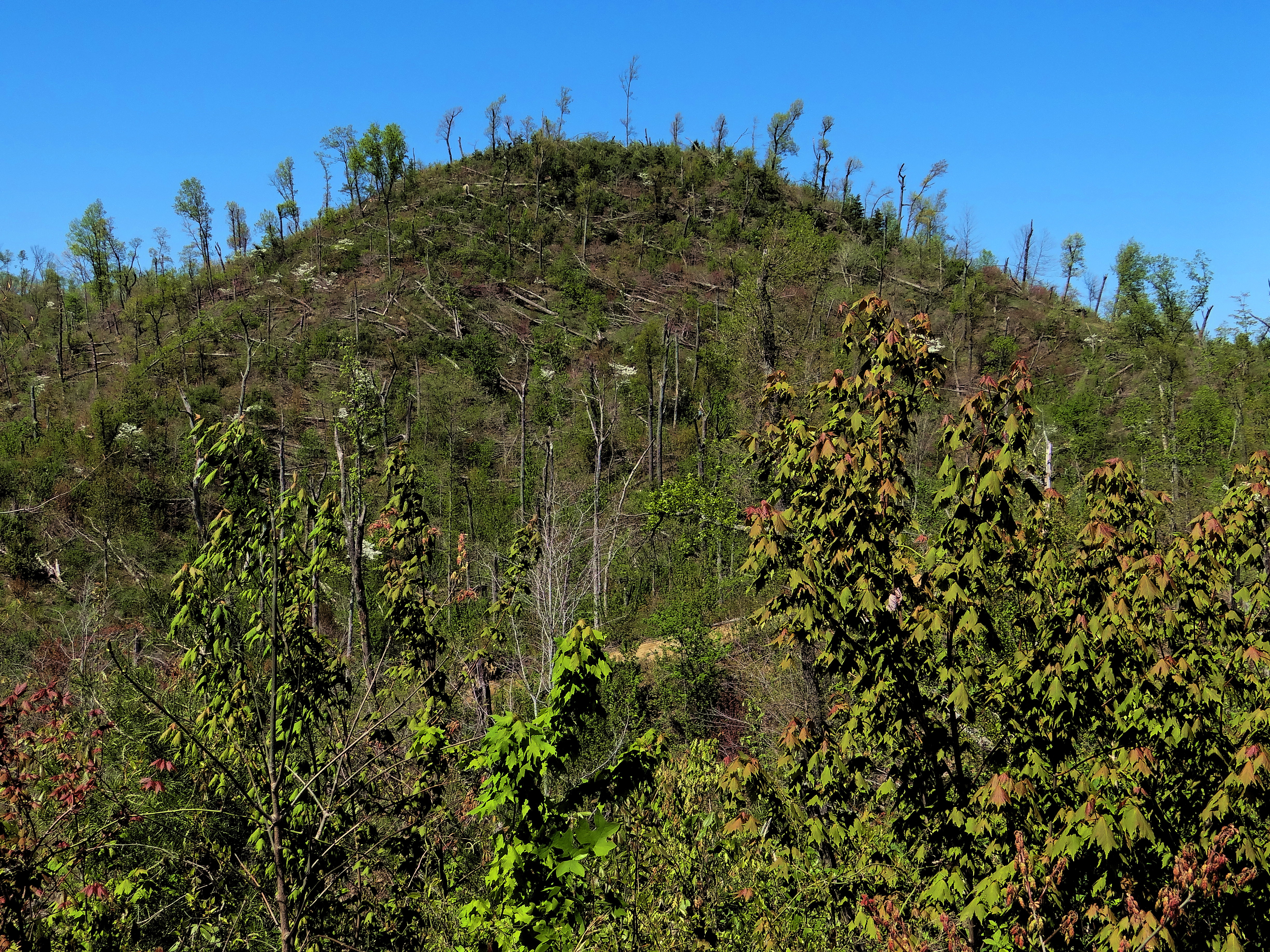
The top of Round Knob allowed us to see for miles in every direction! Here Lyndy pauses to take in view. Or give a speech, not sure which…

One of the interesting things we found on Round Knob were rock carvings dating back over a 100 years.

We had many, many stream crossings throughout the length of the trail. Some were easy to cross, others, not so much. Here Tonya uses a handy log to help her across. The rest of us did not have enough confidence in our balance to try that!

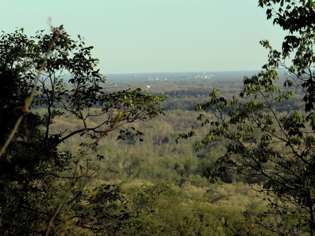
Occasionally we would come across an opening in the trees allowing us a view of Louisville 20 miles to the south.
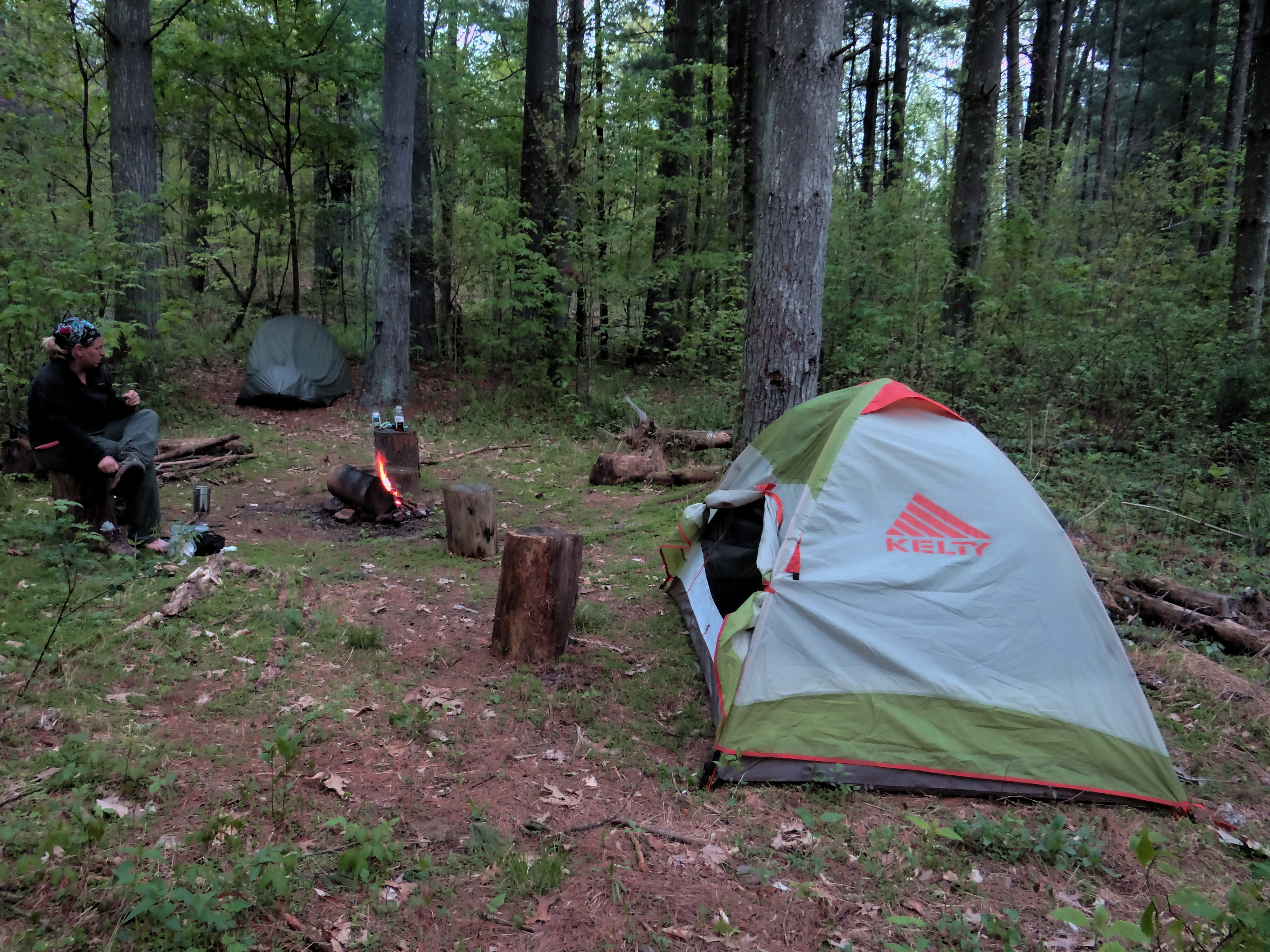
Our goal for the day had been to hike to mile marker 10.85 which would have a campsite with a beautiful view according our guide book. The combination of the uncomfortable night before, our late start, and working through lots and lots of downed trees meant we would be pushing it to make it before dark. We came across a nice campsite just under the 10 mile mark and made the decision to stop there for the night. All in all, not a bad first day. Our campsite was high on a bluff and once darkness fell, we could see the lights of Louisville through the trees. Many of campsites we had passed throughout the day were quite small and would not have had room for 4 tents. This one was nice and roomy although we did opt not to start a fire. The top of the bluff was a little breezy and the tents were a tad too close to the fire ring for our comfort. We cooked dinners with our camp stoves and settled in to sleep shortly after nightfall.

Settled in for the night…

Day 2 Mile 9.8 to Mile 21 And then there were two…
I made it my mission to lighten my pack before this hike and succeeded in shaving 7 pounds from my pack weight. It was still too heavy at 41 pounds (including food and water) but I’m getting there! Some of my weight savings came from using a tent that I had never used before. It was a 2-person Go Lite that was a full 3 pounds lighter than the 3-person I had been using. Obviously it was smaller but the weight savings made less space a sacrifice I was willing to make. It still had room for me to keep my pack inside which I liked. As it turns out though, using untested equipment for a 5 day backpack was a poor idea. The amount of condensation in the tent was unbelievable! Every time I bumped the sides or top, it rained on me. By morning, everything I had was soaked, including my sleeping bag. With temperatures in the upper 30’s at night, being wet meant for a pretty miserable night. Getting out of the tent, I realized it was actually wetter inside than out! This could be a problem… Everyone else seemed to do well with their tents and everyone was up and moving fairly early the next morning. We continued along the ridge for a short distance before starting down a fairly easy downhill stretch. We came across a small stump with a collection of coins in the middle of the trail. It was an odd and unexpected finding but we decided to add some coins of our own. We deemed it the “fairy well” and each made a wish along with our contribution.

Our easy start to the morning was not a predictor of what the day would bring. Mid-morning brought us to “Geronimo Hill” which led us down to the SR 160 crossing. It was a very steep downhill section with wood “steps” built in. Unfortunately, many of the “steps” were missing or in poor repair resulting in metal rods sticking up in random places to trip you up.

As I we made it down to SR 160, I was called over by Tonya for a chat. She told me that she didn’t feel she was up for this hike and thought this was a good place to call for a shuttle. Knowing we still had several long days ahead of us, we supported her decision and helped her secure a ride back to my van. The plan was for her to hang out at Delaney Creek Park until we arrived there. Once we had a ride secured, good bye hugs were given and our group of 3 traveled on. Immediately after crossing SR 160, we were met with a steep uphill. This was complicated further by a large tree across a steep part of the trail. Getting across this proved a fun (that is sarcasm, btw) challenge to not slide down the hill in the process.

Sometimes the challenge wasn’t going over a down tree but rather, going under. Pretty sure we learned some new yoga poses on this trail!

Following the white blazes had been mostly straightforward so far (hint, foreshadowing!) and every so often, we’d come across a KT sign. Always nice to know we were on the right trail!

We stopped for a morning break at a small creek crossing. Lyndy decided to give her feet a break from her boots and cool her heals in the creek. Lyndy struggles with feet problems, especially on trails with steep hills. Despite lots of research on dealing with feet problems and good quality boots, she was already having issues. She ended up losing 8 toenails on the last hike and this hike wasn’t being much kinder to her.

Our next cache drop at the New Chapel trailhead which meant a short diversion from the KT proper on the spur trail leading to the trailhead. Not a big deal aside from the fact that is was an UPHILL diversion. Ugh. As we were heading up the spur trail, Lyndy confided that she didn’t think she was going to be able to complete the hike. This was very sad news since she had done so many hikes, runs and walks with us in preparation for this trail. The steeps hills proved too much for her battered feet. A call was made to Tonya for pickup at the trailhead followed by more good bye hugs. Our goal for day 2 had been to make to mile 22.9 which according to our guide book, had a campsite with a scenic view. We knew we were behind schedule for the day so we did our best to make up time. We did have to stop for occasional pictures. Amazingly enough, the picture stops often coincided with being partway up a strenuous climb. Funny how that worked out! The rain the week before that made life so miserable for the boy scout group meant lots of beautiful wildflowers for us.

After leaving New Chapel, we had a couple of miles of relatively easy hiking. We hit a section of trail where there were lots of trees that were hollowed out at the bases. I’m not a tree expert so I can’t even tell you what kind they were but it seemed to be mostly the same species. We couldn’t resist having a little fun with the hollow trees. 
Soon enough though, we were back into big hills and our goal of making it to just under 23 miles was starting to look unrealistic. We weren’t worried, we had built in a short last day to allow us time to make adjustments along the way. Just a short walk before the mile 21 marker, we found a creek side campsite that looked like a nice place to spend the night. We decided to share dinner that night since we always end up making more than we eat anyway. We also decided that we need to do a better job of planning meals together to lighten the load for each of us. Dinner was stuffing with chicken and it was very tasty! The only issue was the debate over whose chicken packet we were going to use. Both of us were feeling very generous and wanted to contribute the chicken. I’m sure it was all out of the goodness of our hearts and had nothing at all to do with lightening up our packs…

We fell asleep listening to the babbling of the brook beside our tents. I had dreams of waterfalls so realistic I could feel the spray on my face. It was very pleasant until I woke up realizing that the “waterfall spray” was the condensation dripping off the inside of my tent. Despite another night of upper 30’s temps, I had left the ends unzipped a bit to try to cut down on condensation. It didn’t help. I guess my only consolation was it caused me to dream of waterfalls and not water torture!
Day 3 Mile 21 to mile 33 Oh where or where has our little trail gone??
We packed up the next morning and headed out of the ravine. We were rewarded with some easy ridge top hiking to start the day. We had really good cell phone reception the first couple of days but it was getting harder and harder to get a signal the further north we hiked. Becky took the opportunity to check in with home along the ridge top.

Our pleasant ridge walk didn’t last long and we were back in hills. Big hills. Lots of big hills. I don’t remember there being too many particularly interesting things about this section. We did see an occasional deer and turkey. Squirrels were abundant as were the toads. The toads blended in with the leaves and we had to be careful not to step on them!

Despite the big hills, we were making good time. We descended down a hill into a low area beside a lake with many flooded spots. In the course of working around the flooded areas, we managed to lose the trail. At times, we saw what we “thought” were white blazes on trees. Sometimes the patches of scale looked like blazes. Take note, if you go very far at all without seeing a very obvious white blaze, you are not on the right trail! Or possibly, not on any trail at all… After climbing to the top of a steep hill, it was obvious that we were no longer following a trail. We consulted our topo map and it appeared we were too close to the lake. Not wanting to backtrack, we instead opted to continue in the right general direction and hopefully cross back over the KT. Our gps showed us 1 3/4 miles from our next water drop and headed the right direction. This worked well near the lake but as we moved away from it, the terrain became increasingly difficult to traverse. Using the topo, we tried to work our way towards where the trail should be while still moving forward. We eventually climbed to the top of a steep ridge (hoping the trail was there) and found what amounted to a deer path that was a little easier to walk than the sides of the hills. We continued in the direction we needed and to our great relief, eventually found our trail as it crossed over the ridge. We know that we traveled over a mile off trail and probably closer to 1 1/2 miles. This was both tiring and frustrating and put us behind schedule for the day. We managed to think our way through it but definitely would not recommend bushwacking in this area! Our guide book described the hills here as “treacherously steep”. We quite agree! Despite our exhaustion from our off-trail excursion, we made decent time once we were back on the right path. Our goal was to make it to a camp between miles 30 and 31 beside Elk Creek Lake. We were happy to see that we were still going to make our goal before nightfall. As we approached the lake, we decided we would take the first suitable site we came across. We knew we wouldn’t make our water drop until the next morning but wanted to get as close to it as possible. The trail wound around the lake along some steep hills and we saw no place that looked like you could set a tent. As we entered the lower, level areas, it was obvious that the area had been recently flooded. We were tired and at this point had actually hiked further than we were planning. The plan changed from first suitable campsite to the first suitable level spot! We finally located a spot that had obviously been flooded and was still quite damp, but no standing water. While not a “legal” camping spot, it was good enough for us. At that point, we’d had paid a fine just to be able to get our packs off! Dinner was a granola bar and filtered water since neither of us had the energy to cook. Despite our longest hiking day, it was the earliest night we retired to our tents. It turned out to be our least favorite campsite for many reasons. The biggest being too close to “civilization”. We got to listen to some commotion and tires squealing from the trailhead a 1/2 mile away. We were really hoping we were just listening to local kids partying at the lake and not being auditory witnesses to a murder!

Day 4 Mile 33 to mile 41.5 Finally, goal accomplished!
Despite the noise at the trailhead and my wet sleeping bag, I still slept pretty decent. We both woke just as the sun was rising. We packed up without any breakfast because we knew we were just a short hike from our next cache drop which had water for coffee along with snacks that would make an easy and tasty breakfast. The lake had a small layer of mist on the surface and was very peaceful.

Now I definitely wouldn’t want a spider in my tent and I don’t like taking cobwebs to the face on the trail. But I can’t help but admire their amazing webs!

We had read several places about the lack of water on the trail. While I’m sure that’s true certain times of the year, we found quite the opposite. The heavy rains the week before meant that most of the creeks were flowing nicely. We did occasionally come across a dry, or nearly dry creek bed. Of course we couldn’t pass up a cairn without adding a stone!

The rain was not only good for the wildflowers, we saw lots of fungus as well. However, 48 miles total and not one, single morel!

As I said earlier, most of our creek crossings meant crossing water. We both carried water filters “just in case” but only actually filtered water a couple times since we cached water in several places along the way. We could have gotten by with filtering, there were plenty of opportunities, but it was quicker and easier just to have cache drops. Other times of the year, water drops would be a must.

The hills seemed especially big this day although I’m sure they weren’t any bigger than those we’d already climbed. We were in good spirits but our progress was slow. We did come across an area that was very disheartening. We’d been through areas of tornado damage where salvage harvesting had taken place. Makes sense to make use of the destroyed trees in those situations. Today we came across areas of clear cutting. My understanding is that the logging had been done several years prior. The trail wound around piles of left-overs from the logging. Tops of trees and smaller trees that had fallen victim to the larger trees as they fell. We worked our way through big ruts created by the heavy equipment used in the logging operation. Very sad that a trail that is nationally known as a long trail in an area with so few opportunities is being destroyed by clear cutting. Even sadder to later hike through the additional areas marked for logging. One area had almost every mature tree painted up for harvest. We found it ironic that by DNR rules, we could not camp within site of the trail or within a mile of a road, recreation area or trailhead; yet, they will allow logging companies to come in and obliterate the trail altogether. If it really too much to ask that a small section of woods be left to allow the trail to remain intact?

Progress remained slow and by the time we made our final water/cache drop at Oxley Memorial Trailhead, we were running behind and running very low on water. We finally made it to Oxley with the intention of making it a quick restock. Only problem, both our water and ammo can were no where to be found. At this point it was 4:30 in the afternoon and we still had almost 2 1/2 miles to go to make it to our intended stop. There was a creek across the road but filtering would take time. We sat and had a bit to eat while we pondered our options. Going without water was out of the question. We finally settled on putting our remaining water in our water bladders to drink as we finished our hike. The water bottles that we emptied were then filled with water needing boiled or filtered. This water we would use to cook (once treated) and/or filter for drinking water once we made it to camp and could take the time to do so. Problem solved but we were still pretty ticked that our stuff had been taken. Mental note, hide better in the future!

This stop was also the point where we had to do some road walking due to a logging reroute. Snack, rest and probably a bit of anger adrenaline meant we made really good time. The road part was a little scary at one point when we had a couple of large dogs make it clear they were not happy with our presence. They stayed in their yard, however, and we had no other issues. We were surprised to see that the white blazes continued even on the road walk portion. Given our unfortunate off-trail excursion the day before, this was appreciated even if a tad unnecessary.

We found ourselves off the road and back on the trail fairly quickly and continued to make good progress. Still some hills but fortunately they were not coming as frequently. We were tired, however, and briefly considered a stop at the bottom of a long downhill that meant the start of a long uphill. We really wanted to have one night where we made it to our intended destination. We sucked it up and climbed the hill and soon found ourselves meandering through a forest of pines. The smell was wonderful and we knew our intended campsite was in a mature Virginia Pine forest. Excited to be close, we picked up the pace and soon left the pines. Did we miss our campsite? A quick check of our map showed we still had a short way to go. This is an area that obviously has had some TLC as the trail was clear and there were occasional wood carvings from downed trees.

Sadly, this is another area marked for logging as evident by the blue marking on the trees. This was my favorite section of the trail and knowing what is going to come of it was incredibly sad. Soon enough, we came to our campsite. Yeah! We finally made a campsite that we had planned out in advance! It had plenty of room for both our tents and an established fire ring. The smell of pines was rich in the air and we were happy to see that we made it with still a couple of hours of daylight to spare. This was the only night of the trip that we actually made a fire. The plan was for Becky to make dinner and I would get a fire going. Great plan until Becky spilled half of dinner on the ground. Fortunately, we are adaptable and not prone to over-reacting. I did have to give her heck about it but the truth was, I had plenty of food left and didn’t mind at all lightening my pack. We ate, sipped some adult beverages and enjoyed our campfire. Being in a pine forest, we made sure to douse our fire well before going to bed. We used some of our non-treated water that we hadn’t needed for dinner. I had set my tent on a bed of pine needles and was looking forward to a comfy night’s sleep. We had gotten to camp early enough that I could lay out my sleeping bag and dry it out somewhat. It was warmer so I left the doors mostly open on my tent. Warm and dry, that was my hope for the night! (Side note, the actual trail mile for this site is 39.5. The mileage I have listed includes additional mileage due to the reroute.)
Day 5 Mile 41.5 to mile 48 The End!
Well, warm and dry might have been the hope but turned out to be far from reality. By this point, we were pretty tired and sleep was coming quickly. I must not have been tossing and turning too much because I wasn’t getting rained on all night long. That is, until my whole tent collapsed on me about 2 am! The tent is supported on each end by strings that are staked or tied off. The one string decided to break in the middle of the night and bring the whole, wet tent down on top of me. As a testament to my exhaustion, I opted to just stand my pack up in the end of the tent to support it and deal with the broken string in the morning. Not ideal but it worked! Becky did comment though that it was a pretty funny sight to see the next morning. I’d already decided that I was done with this tent after this hike but having it attack me in the middle of the night definitely sealed the deal! Anyone want to buy a tent? We got up the next morning for a quick breakfast. We were excited to know that we would be finishing today! We still had several miles to go, however, and made sure to tend to our sore, blistered feet before heading out.

We had a few hills to deal with in the morning but soon came to choice. We could take the level, valley route to Delaney Creek Lake, or we could head up a steep hill and take the longer, more hilly route. We were torn since a few days earlier the level route was reported to be “impassable”. It looked muddy but did not seem impossible to get through. We were tired of big hills and opted to give it a shot. We did have to route around some flooded areas but ultimately we were glad we took the valley route. It was pretty and easy hiking for several miles which was a welcome change! After much debate (with myself) while packing for this hike, I opted to take 2 cameras. The bigger, heavier one that came very close being left behind was for wildlife and bird photos. My wildlife photography consisted of a few toads and my entire bird collection for the hike is below. A sparrow. It turned out to be a nice picture but still, a sparrow. Of course if I’d have left the “big” camera home, we’d have seen eagles and bobcats and all kinds of exciting things…

The valley section turned out to be a wildflower paradise!

We knew we would be passing Delaney Creek Lake at the end of the hike. We got very excited when we came across this view. Seemed pretty quick though and a quick consult of the topo map showed that this was actually a smaller lake, not our ending destination. Bummer! At this point, we were hearing rumbles of thunder and it was raining lightly off and on. We picked up the pace hoping to beat the approaching storm.

Now this was a sight for sore eyes! Five days earlier, we left Becky’s Subaru at the Delaney Park Trailhead. Many miles, sights and blisters later, we are returning to it. What a great feeling knowing we would soon be completing our journey!

After our long stretch of easy hiking, we came to One. Last. Hill. We can do it, we can do it, we can do it…

Soon after dragging ourselves to the top of the hill, we came across the thing we’d been waiting 48 miles to see. Delaney Creek Lake! For real this time, no more imposter lakes!

Now you would think that after 48 miles and tons of pictures, we’d be ready to snap some fabulous finishing photos. Nope, got some video but completely forgot to take a picture. Fortunately I was able to snag some shots from the video. Not the best quality but honestly, we probably don’t want high-def pictures after 5 days in the woods. Might be a little scary!

End of the trail! Longest trail to date for both of us as well as the most days spent on the trail consecutively.

We had planned ahead for our end of trail celebration. We figured we had earned the right to not worry about calories. Fortunately, the storm held off long enough for us to enjoy our chips and cold beer. Our friends had decided to take my van and head north a couple days earlier so it was just Becky and I. Within an hour of us finishing the trail, the storm broke loose with high winds and hail. We had to drive through it to retrieve the remains of our water and cache drops but were very grateful to not still be on the trail. Despite some cold nights, we were very lucky with our weather.

Trail Summary
This is the longest trail in Indiana and as backpacking Hoosiers, one we just had to do. If you live in the Midwest, it is a fun, challenging trail that you can be proud to say you accomplished. If you are lucky enough to live somewhere with mountains, deserts or beaches to hike and explore, I can’t say I could recommend traveling long distances to hike it. Indiana has some beautiful state parks that would be more worthwhile for camping and day hiking if you are limited on time while visiting our great state. If you are planning on hiking the KT, I’d highly encourage you to do it sooner rather than later because of the planned logging. We both are glad we did it, and especially glad we finished it. But we are both very unlikely to do it again. There are too many other trails waiting to be explored. We summed the experience up quite simply. Too much “ow” for too little “wow”.

It’s official if it’s on the Internet. We are officially the herd of turtles hiking club! Great write-up!
LikeLike
Thanks! Can’t wait for Pictured Rocks!
LikeLike
I enjoyed your trip diary very much. I hope to hike the trail this summer.
LikeLike
Thanks! I’m glad you enjoyed it. Hope you get a chance to hike the trail. It is definitely a unique experience in Indiana!
LikeLike
Pingback: The List | Herd of Turtles Hiking Club
Enjoyed reading of your hike on the Knobstone. If you are up for more hiking in southern Indiana, check out the Tecumseh Trail which starts in Morgan-Monroe state forest and ends just north of the Hoosier National Forest. It’s a 42 mile backpacking trail with one AT type shelter. Much closer to your home.
Bonnie
LikeLike
We do plan on hiking Tecumseh Trail as well but probably not until next year. Glad you enjoyed reading about our hike!
LikeLike
Thanks for the write-up! My husband and a couple friends are currently hiking the KT and I am obsessively wondering what it’s like. APPARENTLY there’s not good cell phone service where they are currently, lol. Your write-up made me feel like I have an idea what they’re experiencing, so thank you 🙂
LikeLike
I’m glad it was helpful! I hope your husband and his friends enjoy their hike.
LikeLike
I enjoyed seeing your photos and reading about your experience! I work for the local tourism bureau and am looking for some photos to accompany a story we’re doing on getting outdoors in Southern Indiana. Would it be possible to use some of your photos? Please email me.
LikeLike
I’m glad you enjoyed the blog! I emailed you regarding the use of pictures.
LikeLike
I too have been thru hiking the KT and other trails in indiana. I am an avid photographer if you need other pictures. I also will be writing about these tails soon if you need additional information. We are also a group of middle age hiking woman. Hiking rocks!!!!!
LikeLiked by 1 person
I have hiked the Knobstone Trail 4 times this year. It changes everytime I hike it and the scenery is beautiful. I have some advice for anyone hiking the trail. Bring hiking poles, learn how to do the rest step, and keep your load as light as practically possible. As far as water is concerned If you have a filter you can get water at creek on mile 3, creek on mile 10 under bridge on highway 160, Elk Creek lake and Spurgeon Hollow lake. I typically carry 2 liters of water on my person. you can figure on using 2 liters of water per 10 miles or 3 liters if it is hot and an addition 2 liters for camp at night. Another thing I would recommend is wearing long sleeve pants with the cuffs tucked into socks. there are a lot of ticks and chiggers on the Knobstone so you might want to spray your clothes with permethrin and yourself with repellent. These things will make your hike much more enjoyable and safe.
.
LikeLike
All very good advice! I think this would be a great fall hike but I’m kind of partial to fall!
LikeLike